| EXPLORATION
White hydrogen exploration requires the integration of diverse scientific methodologies to identify, evaluate, and characterize geological reservoirs where this gas is generated, migrated, and accumulated underground. The process combines remote sensing, geophysical, geochemical and radiometric, ensuring efficient and sustainable results.
Multispectral Satellite Images
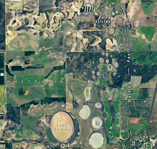 Circular depressions in the northern Perth Basin, Western Australia, imaged with the Landsat 9 instrument — OLI-2.
Source: (NASA, 2023).
Circular depressions in the northern Perth Basin, Western Australia, imaged with the Landsat 9 instrument — OLI-2.
Source: (NASA, 2023).
Identifies surface alterations, thermal anomalies and vegetation patterns associated with hydrogen leaks.
Examples: OLI/TIRS (Landsat), MSI (Sentinel-2), ASTER, MODIS.
Hyperspectral Satellite Images
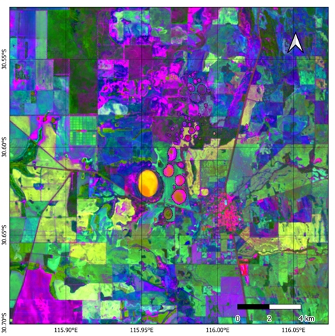 Hyperspectral image in the Perth Basin, Western Australia, obtained with the PRISMA sensor
Source: (Mosquera-Rivera et al., 2024).
Hyperspectral image in the Perth Basin, Western Australia, obtained with the PRISMA sensor
Source: (Mosquera-Rivera et al., 2024).
They capture hundreds of spectral bands to characterize soil mineralogy and detect geochemical signatures of hydrogen seeps.
Examples: Hyperion (EO-1), PRISMA, EnMAP, DESIS.
Synthetic Aperture Radar (SAR)
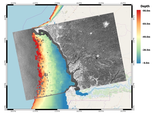 Bathymetry retrieved from a Sentinel-1 scene of West Africa, acquired on 2017-03-08.
Source: (Wiehle & Pleskachevsky, 2018).
Bathymetry retrieved from a Sentinel-1 scene of West Africa, acquired on 2017-03-08.
Source: (Wiehle & Pleskachevsky, 2018).
It maps variations in humidity and relief, allowing the identification of geological structures and hydrogen escape zones.
Examples: Sentinel-1, ALOS PALSAR, TerraSAR-X, RADARSAT.
Digital Elevation Models (DEM)
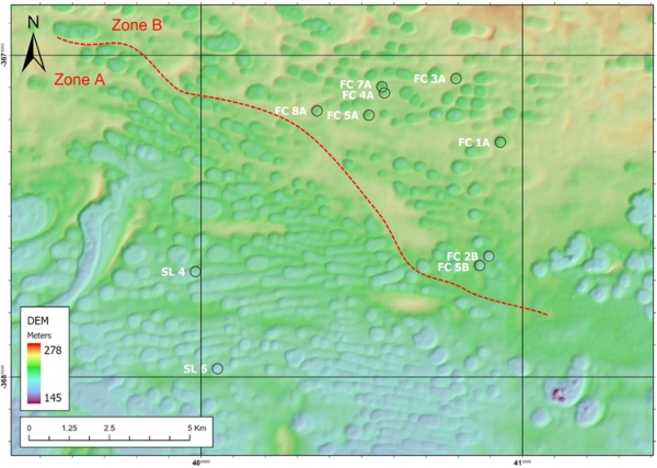 Digital Elevation Model (DEM) of the Grass Patch area , Western Australia, generated from digital photogrammetry by Landgate (2017).
Source: (Aimar et al., 2023).
Digital Elevation Model (DEM) of the Grass Patch area , Western Australia, generated from digital photogrammetry by Landgate (2017).
Source: (Aimar et al., 2023).
It analyzes the topography, identifies depressions and correlates them with possible hydrogen seepage zones.
Examples: SRTM, ALOS PALSAR DEM, Airborne LiDAR , Digital Photogrammetry (Landgate).
Magnetometry
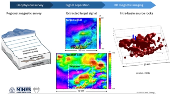 Identification and modeling of intrabasin igneous rocks using advanced signal separation and 2D inversion of magnetic data.
Source: (Li et al., 2012).
Identification and modeling of intrabasin igneous rocks using advanced signal separation and 2D inversion of magnetic data.
Source: (Li et al., 2012).
It identifies favorable structures for hydrogen accumulation (faults, salt diapirs, serpentinized bodies ) without drilling. Its ability to identify magnetic variations allows for the rapid, efficient, and cost-effective delineation of hydrogen flows.
Gravimetry
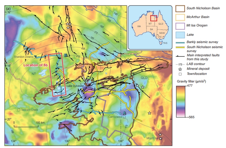 Gravimetric map of the South Nicholson Basin, Australia.
Source: (Boreham et al., 2023).
Gravimetric map of the South Nicholson Basin, Australia.
Source: (Boreham et al., 2023).
It detects deep structures, such as faults and sedimentary basins, that can act as conduits or traps for hydrogen accumulation.
Reflection Seismic
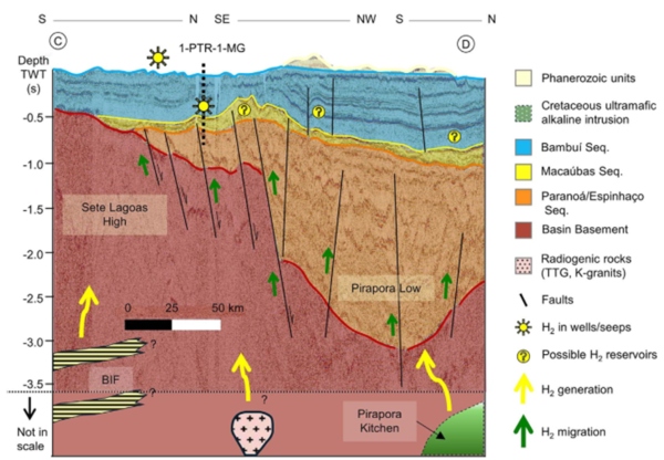 2D reflection seismic profile of the São Francisco Basin, Brazil, showing H₂ generation and migration zones associated with geological units and magnetic anomalies.
Source: (Freitas et al., 2024).
2D reflection seismic profile of the São Francisco Basin, Brazil, showing H₂ generation and migration zones associated with geological units and magnetic anomalies.
Source: (Freitas et al., 2024).
Provides detailed images of the subsurface, allowing for the identification of favorable structures such as faults, fractures, and sealed traps. Its high resolution helps delineate H₂ migration and accumulation routes.
Audio-Magnetotelluric (AMT)
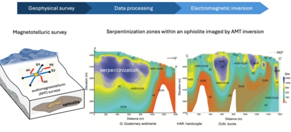 Electrical resistivity sections, obtained by (AMT), reflecting different areas potentially related to the generation of H₂.
Source: (He et al., 2018).
Electrical resistivity sections, obtained by (AMT), reflecting different areas potentially related to the generation of H₂.
Source: (He et al., 2018).
A high-frequency electromagnetic method that allows mapping of shallow and medium geological structures. It is used to identify hydrogen generation zones in source rocks and to detect serpentinization in ultramafic rocks based on variations in electrical resistivity.
Magnetotelluric (MT)
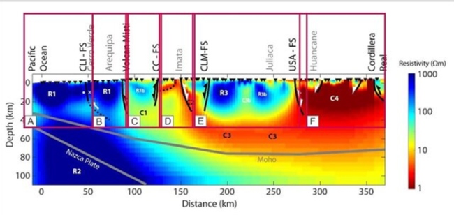 MT profile showing subsurface resistivity in southern Peru, from the Pacific Ocean to the Cordillera Real.
Source: (Quispe-Rentería et al., 2021).
MT profile showing subsurface resistivity in southern Peru, from the Pacific Ocean to the Cordillera Real.
Source: (Quispe-Rentería et al., 2021).
A low-frequency electromagnetic method that allows exploration at great depths. It can be used to delineate deep structures, such as faults, sedimentary basins, and fracture systems, which can act as conduits or traps for hydrogen migration.
Controlled Source Electromagnetic Methods (CSEM)
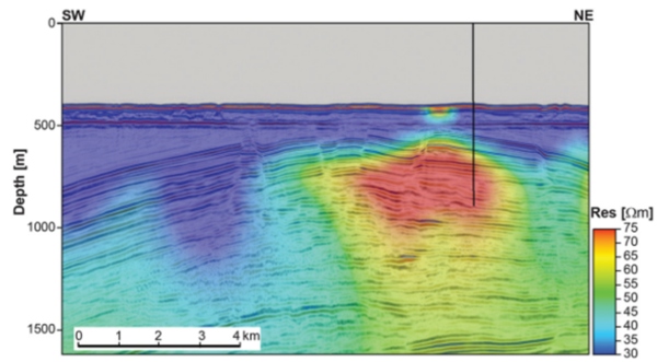 Resistivity profile obtained by 2D inversion of CSEM electromagnetic data in the Barents Sea, Norway.
Source: (Fanavoll et al., 2014).
Resistivity profile obtained by 2D inversion of CSEM electromagnetic data in the Barents Sea, Norway.
Source: (Fanavoll et al., 2014).
It uses an artificial electromagnetic source to map resistivity variations in the subsurface. It can help delineate conductive or resistive bodies, such as accumulations of free gas in porous rocks, which exhibit higher resistivity compared to areas saturated with saline water.
Gamma Spectrometry
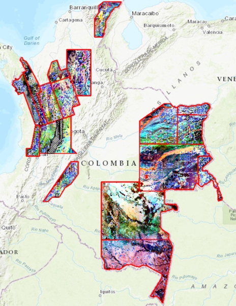 Map of radiometric anomalies in Colombia, highlighting areas with high levels of naturally occurring radioactive elements (K, Th, U).
Source: Agencia Nacional de Hidrocarburos (ANH).
Map of radiometric anomalies in Colombia, highlighting areas with high levels of naturally occurring radioactive elements (K, Th, U).
Source: Agencia Nacional de Hidrocarburos (ANH).
Used to map rocks with high content of radioactive elements that could generate H₂ by Water Radiation.
Gas analysis
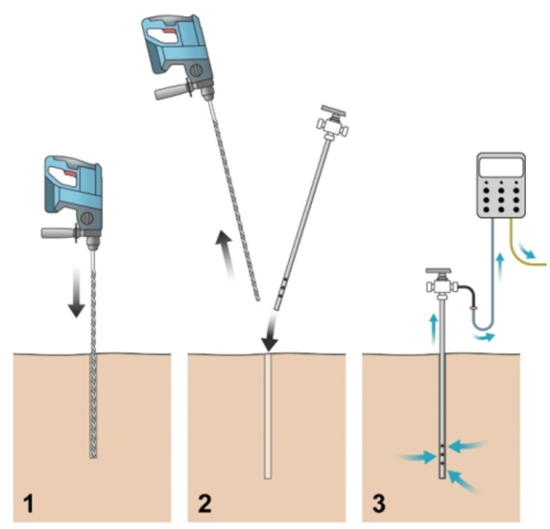 Traditional method of measuring soil hydrogen. 1: Drilling, 2: pipe installation. 3 : Measurement and eventual sampling through the valve.
Source: (Patiño et al., 2024).
Traditional method of measuring soil hydrogen. 1: Drilling, 2: pipe installation. 3 : Measurement and eventual sampling through the valve.
Source: (Patiño et al., 2024).
Geological hydrogen detection in the field is carried out with portable sensors. For surface sampling, small holes are drilled with portable drills and fitted with electrochemical or semiconductor detectors calibrated to measure hydrogen.
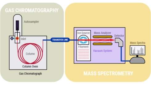 Diagram of the GC-MS system, where compounds are separated by gas chromatography and identified by mass spectrometry.
Source: (PerkinElmer, 2022).
Diagram of the GC-MS system, where compounds are separated by gas chromatography and identified by mass spectrometry.
Source: (PerkinElmer, 2022).
A physicochemical technique that separates and quantifies the components of a gaseous mixture (such as H₂ , CH₄ , or CO₂ ) to characterize its composition. Detection of H₂ requires the use of a thermal conductivity detector (GC-TCD) or a system coupled to mass spectrometry (GC-MS) with appropriate configuration.
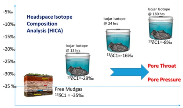 Headspace isotopic composition analysis (HICA) of shale cuttings or coal chips.
Source: (Wu et al., 2020).
Headspace isotopic composition analysis (HICA) of shale cuttings or coal chips.
Source: (Wu et al., 2020).
Technique that measures the proportion of stable isotopes (¹³C/¹²C, ²H/¹H, ³He/ ⁴ He) to determine the origin and the processes that generated the gases, such as microbial activity (biogenic ) or geological reactions (abiogenic).
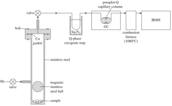 IRM -GCMS system for extracting, separating, and isotopically analyzing gases from fluid inclusions in rocks.
Source: (Grozeva et al., 2020).
IRM -GCMS system for extracting, separating, and isotopically analyzing gases from fluid inclusions in rocks.
Source: (Grozeva et al., 2020).
Analytical technique that combines gas chromatography and mass spectrometry to separate compounds and analyze their isotopic ratios, used in the study of fluid inclusions and in determining the origin of gases in rocks.
Characterization of Rocks and Fluids
 Mafic cumular rock with allotriomorphic olivine altered to iddingsite , polysynthetic twinned plagioclase, hexagonal apatite, and opaque mineral.
Source: (Departamento de Petrología y Geoquímica, 2013).
Mafic cumular rock with allotriomorphic olivine altered to iddingsite , polysynthetic twinned plagioclase, hexagonal apatite, and opaque mineral.
Source: (Departamento de Petrología y Geoquímica, 2013).
Used to identify hydrogen-generating minerals, evidence of serpentinization, and allows for the establishment of paragenetic sequences and understanding of rock formation and alteration events, essential for interpreting the geological processes associated with hydrogen generation.
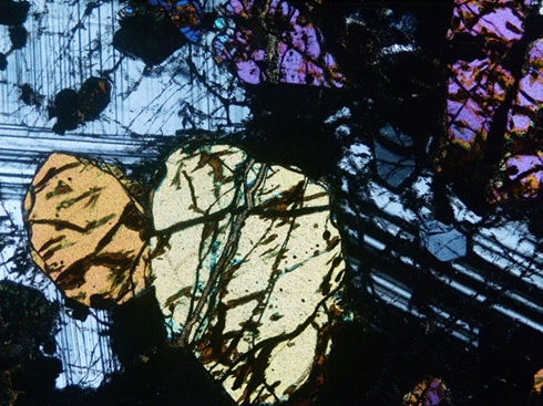
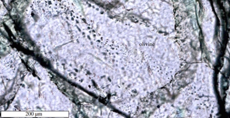 Olivine crystal with fluid inclusions distributed along fractures and growth planes.
Source: (Grozeva et al., 2020).
Olivine crystal with fluid inclusions distributed along fractures and growth planes.
Source: (Grozeva et al., 2020).
Allows the analysis of fluid inclusions trapped in minerals, in order to obtain a first approximation of the processes of fluid formation or evolution, as well as evidence of circulation and geological events associated with hydrogen.
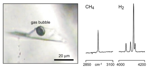 Raman analysis of H 2 and CH 4 in vesuvianite fluid inclusion, Italian Alps .
Source: (Ferrando et al., 2010).
Raman analysis of H 2 and CH 4 in vesuvianite fluid inclusion, Italian Alps .
Source: (Ferrando et al., 2010).
It directly identifies the composition of fluid inclusions, detecting hydrogen, as well as the mineralogy associated with hydrogen-generating processes, such as magnetite, types of serpentine, brucite and others.
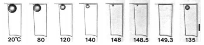 Photomicrographs of an aqueous inclusion during microthermometry, showing the disappearance and renucleation of the bubble when the homogenization temperature (Th) was determined by cycling.
Source: (Goldstein & Reynolds, 1994).
Photomicrographs of an aqueous inclusion during microthermometry, showing the disappearance and renucleation of the bubble when the homogenization temperature (Th) was determined by cycling.
Source: (Goldstein & Reynolds, 1994).
This involves heating or cooling inclusions to determine fluid trapping temperatures and salinity. It allows for the reconstruction of pressure-temperature conditions and the evaluation of the origin and evolution of H₂-generating fluids in geological contexts such as serpentinization.
Mapping
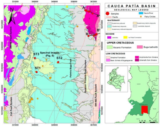 Mapping of the Cauca Valley-Patía study area, an area with potential for natural hydrogen exploration.
Source: (Carrillo et al., 2023).
Mapping of the Cauca Valley-Patía study area, an area with potential for natural hydrogen exploration.
Source: (Carrillo et al., 2023).
It allows to identify favorable lithologies, tectonic structures and alteration zones associated with the generation and migration of hydrogen , guiding the sampling and delimitation of prospective areas.
Permeability and Porosity Assessment
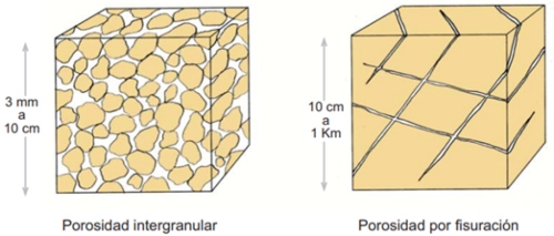 Types of porosity in rocks, key to the storage and flow of hydrogen in the subsurface.
Source: (Sánchez, 2022).
Types of porosity in rocks, key to the storage and flow of hydrogen in the subsurface.
Source: (Sánchez, 2022).
Allows quantification of the capacity of rocks to store and conduct fluids, essential for determining the feasibility of hydrogen accumulation and flow in the subsoil.
Water Analysis
 Laboratory analysis of liquid samples for the physicochemical characterization of groundwater.
Source: (Aguas Urbanas, 2018).
Laboratory analysis of liquid samples for the physicochemical characterization of groundwater.
Source: (Aguas Urbanas, 2018).
Characterizes groundwater or surface water using physicochemical and isotopic parameters (pH, Eh, δ²H, δ¹ ⁸ O) to detect dissolved H ₂ and indirect evidence of deep generation processes.
Hydrogeology
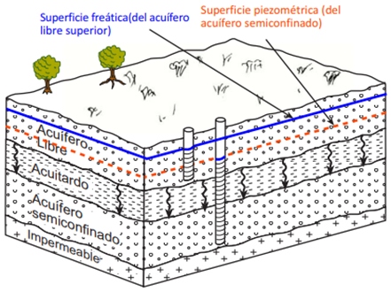 EsquemaConceptual diagram of a hydrogeological system showing recharge, groundwater flow, and water abstraction in aquifers.
Source: (Sánchez, 2022).
EsquemaConceptual diagram of a hydrogeological system showing recharge, groundwater flow, and water abstraction in aquifers.
Source: (Sánchez, 2022).
It studies the flow and origin of groundwater, which is key to understanding the transport and release of hydrogen from deep areas, and to modeling systems that control its migration and accumulation.
Bibliographic references
- Aguas Urbanas. (2018). Monitoreo de variables físico-químicas de agua. Recuperado el 15 de abril de 2025, de - Check this reference here
- Aimar, L., Frery, E., Strand, J., Heath, C., Khan, S., Moretti, I., & Ong, C. (2023). Natural hydrogen seeps or salt lakes: how to make a difference? Grass Patch example, Western Australia. Frontiers in Earth Science, 11, 1236673. - Check this reference here
- Alaska Satellite Facility. (2025). ASF Data Search. Alaska Satellite Facility. - Check this reference here
- Boreham, C. J., Golding, S. D., & Sherwood Lollar, B. (2023). Hydrogen in Australian natural gas occurrences, sources and resources. The APPEA Journal, 63(1), 170-185. - Check this reference here
- Carrillo Ramirez, A., Gonzalez Penagos, F., Rodriguez, G., & Moretti, I. (2023). Natural H2 Emissions in Colombian Ophiolites: First Findings. Geosciences, 13(12), 358. - Check this reference here
- Departamento de Petrología y Geoquímica. (2013). Olivino. Atlas de Rocas Ígneas. - Check this reference here
- Fanavoll, S., Gabrielsen, P. T., & Ellingsrud, S. (2014). CSEM as a tool for better exploration decisions: Case studies from the Barents Sea, Norwegian Continental Shelf. Interpretation, 2(3), SH55–SH66. - Check this reference here
- Ferrando, S., Frezzotti, M.L., Orione, P., Conte, R.C., Compagnoni, R., 2010. Late-Alpine rodingitization in the Bellecombe meta-ophiolites (Aosta Valley, Italian Western Alps): evidence from mineral assemblages and serpentinization-derived H2-bearing brine. International Geology Review 52, 1220–1243. DOI: 10.1080/00206810903557761
- Freitas, V. A. de, Prinzhofer, A., Françolin, J. B., Ferreira, F. J. F., & Moretti, I. (2024). Natural hydrogen system evaluation in the São Francisco Basin (Brazil). Science and Technology for Energy Transition, 79, 95. - Check this reference here
- Goldstein, R. H., & Reynolds, T. J. (1994). Fluid inclusion microthermometry. En Systematics of fluid inclusions in diagenetic minerals (Cap. 7, pp. 87–121). SEPM (Society for Sedimentary Geology). ISBN 1-56576-008-5.
- Grozeva, N.G., Klein, F., Seewald, J.S., & Sylva, S.P. (2020). Chemical and isotopic analyses of hydrocarbon-bearing fluid inclusions in olivine-rich rocks. Philosophical Transactions of the Royal Society A, 378:20180431. - Check this reference here
- He, L., Chen, L., Dorji, He, Z., Wang, X., Xiao, B., Xu, L., Zhao, X., Xi, X., Yao, H., & Chen, R. (2018). Mapping chromite deposits with audio magnetotellurics in the Luobusa ophiolite of southern Tibet. Geophysics, 83(2), B47–B57. - Check this reference here
- Li, Y., He, Z., & Liu, Y. (2012). Application of magnetic amplitude inversion in exploration for volcanic units in a basin environment. Geophysics. - Check this reference here
- Mosquera-Rivera, J. E., Jiménez-Vergara, J. M., Vargas-Jiménez, C. A., Ball, P., & Morales, H. (2024). Preliminary remote spatial analysis of fairy circles: an approximation of hyperspectral and geophysical data from hydrogen seeps. First Break, 42, 65-77. - Check this reference here
- NASA Earth Observatory. (2023). Circular Depressions Seep Hydrogen Gas - Check this reference here
- Patiño, C., Piedrahita, D., Colorado, E., Aristizábal, K., & Moretti, I. (2024). Natural H₂ Transfer in Soil: Insights from Soil Gas Measurements at Varying Depths. Geosciences, 14(11), 296. - Check this reference here
- PerkinElmer. (2022). Chromatography Explained: How Mass Spectrometry Adds Information to Your Analysis. PerkinElmer Blog. Recuperado el 15 de abril de 2025, de - Check this reference here
- Quispe-Rentería, L. Y., Torres-Bazán, V., Marchena Campos, A. A., Acosta Ale, J., Calla, D., Flores, R., Valencia, C., & Fernández, C. (2021). Interpretación de Datos Magnetotelúricos de la Transecta del Sur del Perú y su Relación con la Metalogenia. Instituto Geológico Minero y Metalúrgico (INGEMMET). - Check this reference here
- Sánchez, F. J. (2022).- Hidrología Superficial y Subterránea. 2ª ed. Kindle Direct Publishing., 440 pp.
- Wiehle, S. & Pleskachevsky, A. (2018) “Bathymetry derived from sentinel-1 synthetic aperture radar,” in Proc. Eur. Conf. Synthetic Aperture Radar. pp. 747–750. At: - Check this reference here
- Wu, S., Tang, Y., Lin, M., & Sneddon, A. (2020). Headspace isotope & compositional analysis for unconventional resources: Gas in place, permeability and porosity prediction and completions planning. Geosciences, 10(9), 370. - Check this reference here